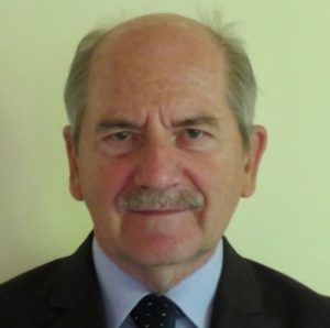
Gábor Remetey-Fülöpp
He wrote his diploma theses on the subjects of airport landing system validation and Landsat Earth observation satellite data preprocessing.
He began his professional career as a topographer, then spent 10 years in the IT group of the Water Engineering Company (VIZITERV) in an IBM technical development environment, later at a management level. In the meantime, he became involved in the Hungarian work of the Surveying and Remote Sensing Institute (FÖMI) on satellite Doppler network equalization. He became acquainted with the quantitative analysis of remote sensing as a scholarship holder at the Delft University of Technology (Netherlands) in 1977.
Between 1980 and 1986, he headed the digital processing department at the remote sensing department of the Hungarian Institute of Geodesy and Geosciences, and then moved to the Department of Land and Cartography of the Ministry of Agriculture (MOA), where he coordinated the remote sensing and geoinformatics R&D (research and development) work of the department at the senior advisor level. He was also responsible for launching the land office IT Phare program and for the land and remote sensing tasks related to EU accession.
Until his retirement in 2007, he was responsible for international R&D cooperation in the field of land administration. He represented the sector at meetings of the European Surveying and Mapping Authorities (CERCO, later known as Eurogeographics), the UNECE Land Administrations (MOLA, later known as WPLA) and the EU Standing Cadastral Committee.
In the field of informatics, he participated in the European Space Agency (ESA) Earthnet and Intercosmos programs in the field of satellite remote sensing since the early 1980s; he participated in study tours to India and the USA. In 1989, he graduated from the ESA Alpbach Summer School and was a fellow at the European Commission's Directorate-General XIII (Information and Communication) in 1994.
He was elected as the head of the VII. working committee of the International Society for Photogrammetry and Remote Sensing (ISPRS) between 1996 and 2000. He participated in the domestic organization of nearly 20 international conferences, symposia and workshops between 1985 and 2015. He is an editorial advisor to seven international journals and scientific magazines. Between 1994 and 2015, he was the Secretary General of the Hungarian Geospatial Information Society (HUNAGI) and was a board member of several international societies (UNECE WPLA, EUROGI, GSDI, ISDE). He is a lifelong member of the Hungarian Society for Surveying, Cartography and Remote Sensing and the International Society for Digital Earth (ISDE) (since 2007 and 2016, respectively).
Since 2006, he has been participating in the work of the Geneva-based Group on Earth Observations (GEO) and the Working Group on Information Systems and Services (CEOS WGISS) of the Committee on Earth Observation Satellites. Between 2006 and 2015, he was a member of the Hungarian Space Research Council, since November 2019, of the Space Research Scientific Council, and of the ISDE Digital Earth Summit 2020 scientific committee. From 1971 until the end of the 1980s, he was also a member of the National Space Research Organization.
His awards: Nagy Ernő Award (MTESZ MANT, 1984); Fasching Antal Award (Ministry of Agriculture and Rural Development, 2004); For Hungarian Informatics (Ministry of Informatics and Communications, 2005); For Agricultural Informatics (Hungarian Agricultural Informatics Association, 2006); FAO Award (UN FAO European Subregional Office, 2006).
- Certificates of recognition: from the International Society for Photogrammetry and Remote Sensing (ISPRS) (2001) and from the United Nations Working Group on Geospatial Information (UN WGGI) (2013).
- Hobbies: nature, geography, travel and photography.
Created: 2019.12.02. 18:53
Last modified: 2024.04.18. 12:42

