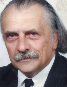
Karácson Eöry
From 1967 he worked on the geodetic surveys of rural excavations at the National Museum; then he carried out geodetic works primarily related to bauxite mines and aluminum-industrial facilities at the Geodetic Department of ALUTERV (Aluminum Industry Design Company), as well as surveys of archaeological objects commissioned by the Savaria Museum in Szombathely (Velem, Petőmihályfa, Vasvár, Karakó, etc.). During this time he participated as an expert in the mapping of the Vietnamese bauxite treasure.
In 1970, he supervised the aerial photography of Vas County, and he also wrote his archaeological thesis on photo interpretation.
From 1980 to 1985, he was the chief engineer of the geodesy department supervising the safe and planned implementation of the Paks Nuclear Power Plant project, where a closed-loop automated and interactive photogrammetric graphic information system was designed and implemented to perform the task.
He participated in solving various photogrammetric tasks of the POWER PLAN.
From 1986 to 2000, he was the head of the INFORT Research-Development-Production Association, founded by the Metropolitan Land Office and the Ministry of Industry, as well as the GmbH and Bt. of the same name.
From 1992 to 1993, he was an expert at the Budapest Metropolitan Administrative Office.
He initiated the domestic application of a municipal GIS system introduced in Canada and created the concept of the Territorial Technical Database (TMAB).
Eőry K.: Basic geodetic calculations with an electronic pocket calculator, Geodesy and Cartography, Vol. 24, No. 1 (1972)
Eöry K. – E. Szabó I.: Aerial Photo Interpretation for Regional Field Research in Archaeological Topography, published by the Geodesy and Cartography Association, 1972.
• In 1973, the Márványkő Castle was excavated with his participation.
• From 1994 to 2004, he was the Secretary General of the Holy Crown Association.
Created: 2023.02.03. 21:58
Last modified: 2023.02.03. 22:28

