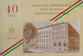
Hungarian Defence Forces Cartographic Office
Military cartography, aerial survey, paper and digital map making.
- Laszlo Cseri,
- Laszlo Buga,
- Rezso Berencei,
- Gyula Szabo,
Maps. DTA-50; DTA-200; DDM-50; DDM-10.
Hungarian Topographic Program.
Company history: The decree of the Minister of War on February 4, 1919, called into being the “Hungarian Military Cartographic Group”. From this developed the MH (Ágoston Tóth) Cartographic Office (Institute). The Office was split into two on January 1, 1994. The MH TÁTI, responsible for military geodesy, aerial photography, cartographic research and map supply. The MH KARTÜ (Cartographic Plant), GIS development, topography, relief map production. Director: Béla Szabó, Chief Engineer: László Buga. The two institutions were reunited in October 1996 under the name MH TÉHI (MH Cartographic Office). Head of Office: Colonel József Cseri. Cseri retired on December 1, 1999. He is responsible for the DTA-50 digital map, the multimedia GIS system of the Central Shooting Range, the foundation of the Hungarian Topographic Program, and participation in NATO accession. Later name changes: Managing organization: MH Mapping Service from December 1, 2000 to 2007, then MH Geoinformation Service, the names of the producing institute: Ministry of Defense Mapping Public Benefit Company (December 2000), Ministry of Defense Mapping Public Benefit Nonprofit Ltd. (2009), Ministry of Defense Zrínyi Mapping and Communication Service Public Benefit Nonprofit Ltd. (2013).
Created: 2024.02.03. 20:12
Last modified: 2024.06.25. 10:30

