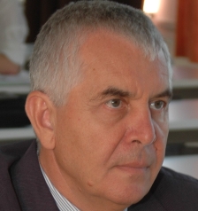
Béla Márkus
In 1967, he wrote his first software for the Razdan-3 computer of the Budapest University of Technology (BME). From 1971, he taught for 22 years at the Department of General Geodesy of BME. In 1973, he completed his doctoral dissertation on the topic of computer optimization of geodetic networks. In his PhD thesis, defended in 1986, he dealt with the development and analysis of digital terrain models supporting automated technical design.
Between 1992 and 1994, he organized the localization project of the "NCGIA Core Curriculum" developed in the United States - involving lecturers from five Hungarian universities, four GIS companies, three research institutes and staff from the Ministry of Agriculture. The four-volume work formed the basis for GIS education nationwide.
In 1994, the University of Sopron invited him to establish the first Hungarian Department of Geospatial Information. In the period 1995-2000, he led several international projects to meet the educational and training needs of land offices and related institutions. In 1995, the department became a member of the international geospatial university network UNIGIS. In 1999, he founded the “uniGISopen – for open geospatial education” Foundation, of which he has been the president ever since.
He participated in the organizing committees of several domestic and foreign Geographic Information System (GIS) seminars and conferences (e.g. Szolnok Geographic Information Conference, First European GIS Education Seminar, International Federation of Surveyors (FIG)). In 1997, he organized the first GISopen conference, which has been held annually since then.
In 1998, the "Internet-based Land Information Services System" (FISH project) was developed under his leadership at the Surveying and Remote Sensing Institute (FÖMI).
He was a member of the Board of Directors of the international distance learning network EUROPACE (2001-2010), the Presidency of the “AGILE - Association of GI Laboratories in Europe” (2001-2006), Chairman of the FIG “Knowledge Transfer in Spatial Information Management” working group (2002-2006), and was elected Chairman of the FIG Education Committee (2006-2010).
He was appointed as a university professor in 1999. Between 2001 and 2008, he was the Director General and then Dean of the Faculty of Geoinformatics of the University of West Hungary (NYME).
In the first two decades of the 2000s, he participated in the management of approximately 20 international education development projects, which were fundamentally aimed at the utilization of geographic information systems.
His awards: Antal Fasching Award (Minister of Agriculture and Rural Development, 2005); Knight's Cross of the Order of Merit of the Republic of Hungary (President of the Republic, 2009); Lázár Deák Memorial Medal (Hungarian Society of Surveying, Cartography and Remote Sensing, MFTTT, 2009).
Created: 2020.02.10. 17:13
Last modified: 2024.03.31. 14:58

