Gita Conference 2022
XVII. Gita Technical Geospatial Information Conference.
During the 30-year history of the gita Technical Geospatial Information Association, the technology of geospatial information and data management has changed a lot, modernization, digitalization, the strengthening of climate protection considerations, and changes in energy prices all have a direct impact on our industry. In 2021, unfortunately, similarly to the previous year, the pandemic that hit the world determined our everyday lives, in addition, the challenges facing the energy and utility sectors, the increasing social demand for sustainable and environmentally friendly technologies, and the simultaneously emerging decentralization and centralization trends are also continuously rewriting our plans. In our changing world, keeping our knowledge up to date and informal connections are becoming increasingly important, so by holding our conference, we want to provide our colleagues and partners with an opportunity to renew themselves.
The planned topics of our conference are:
• BIM and GIS,
• digital image processing,
• artificial intelligence applications,
• business and big data analyses,
• electronic, automated customer service solutions,
• challenges in developing and simplifying the public administration data provision system,
• and the application of modern technological solutions in utility companies, municipalities and state administration.
Workshop:
On June 9-10, they dealt with digital image processing in Esztergom . In addition to basic image processing operations, they also looked into the possibilities offered by artificial intelligence. In addition to all the tasks raised, Python sample examples were also presented using free software libraries (e.g. OpenCV, Scikit-learn).
- gita Technical Geoinformatics Association
- Gábor Csemez, Tamás Prajczer GeoX Ltd. (500,000 locations beyond addresses); Péter Baranyi Arkance Systems HU Ltd. (Infrastructure BIM 7D + twiGIS BIM4GIS = SPATIAL INFORMATION 4.0); Dr. Zoltán Siki BME Faculty of Civil Engineering (Digital Image Processing Workshop); Dr. Tamás Tomor Envirosense Hungary Ltd. (Digital spatial data and maps at the service of local governments, utility providers and state administration); István Elek ELTE Faculty of Informatics (A quantum-computing-safe encryption method); Érsek Akos GPSCOM Ltd. (Circular GIS data collection tools and technologies); Gábor Pusztai Budapest Public Roads Ltd. (Integration of the Budapest GIS Portal into the KAPU system); Péter Gruhala Geometria Ltd. (Utilization of spatial information in knowledge management); Péter Hargitai GeoAdat Ltd. (Survey and evaluation of low-voltage networks fixed on electrical support structures using modern technological solutions); Márk Pálinkás Arkance Systems HU Ltd. (Spatial information-supported settlement planning in AutoCAD Map3D, specifically E-SPACE); Tamás Prajczer GeoX Ltd. (How spatial data supports machine learning)? - Speakers
The conference presentations can be read here.
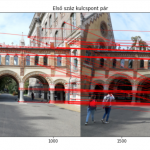
In our gallery: Finding keypoint pairs in photos taken from different perspectives. This is a necessary intermediate step in generating a point cloud from images.


